Google Maps is an informational hub for location-based data that many of us rely on. Whether you’re planning a road trip, or simply looking for directions, Google Maps is oftentimes the go-to tool.
With the amount of features that Maps has, it’s really no wonder why. From navigating to your favorite places to creating custom maps with My Maps, it brings a lot to the table. One lesser-known feature of Google Maps, but a useful one, is the ability to view county lines.
How to View a Single County on Google Maps
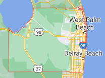
To view county lines of a single county in Google Maps, simply open Google Maps and search for the county’s name followed by “county”.
The example below shows the results for “Palm Beach County” in Florida. The red line depicts the border of the county.
How to View All Counties on Google Maps
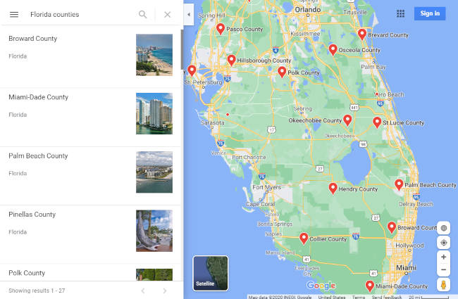
To view all counties of a state in Google Maps, start by searching for the state followed by “counties”.
Maps will show a list of counties on the left with markers for each one on the map. Simply click the county in either the list or the map to view its line.
Use the back button in your browser to view the list of counties again if you wish to view another one.
To view multiple county lines all at once, you might try this custom map by Randy Majors. This maps shows all of the county lines that make up each state. You can click a county on the map to find out its name.
Sharing / Embedding a Map with Counties Shown
Another cool feature of Google Maps is that it allows you to share a link to, or embed on a website, a map as you see it on your screen. You can use this to share or embed a map of counties directly from Google Maps.
- Open Google Maps and search for “<State> counties”, or a single county, like shown above.
- Click the
Hamburger menuicon ( ) in the upper left corner and select
 Share or embed a map.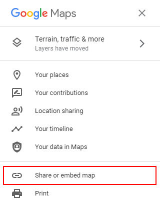
- To share a link to the map, copy the link under the
Send a linktab. - To embed a map, copy the HTML under the
Embed a maptab. You can even customize the size of your map by using theSize dropdownto the left of the HTML code. Use the preview window to see how the map will appear to visitors on your website.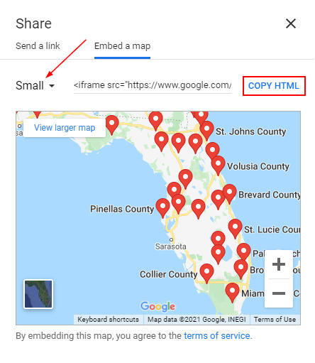


I am interested in this feature implementation as well. Plz keep me posted
Hi Alex:
Thanks for this article. What if you only want to show 2 or 3 counties and not the whole state….any ideas?
Hi Alex,
I’m new to all these things about google maps, and many times I find it difficult to understand. But, I like the simple way you explain “How to View All Counties on Google Maps” and made it very easy to understand.
But, now the question is… not only to view it but how do I get all the counties of a specific State on Google Maps on a webpage? In other words, instead of just viewing it, how can I get this on a webpage? Step by step instructions, please
Thank you much,
-Sam
Hi Sam,
Thanks for commenting!
This is something I would have to look into. My first thought is that you could use Google My Maps to create what you’re looking for but I’m not sure how to get it to show counties there.
You can embed maps you create in Google My Maps.
Do you maybe have a KML file of the counties you want to show? You could, potentially, import that data into Google Maps and embed that.
Thanks for your quick comment and response, Alex. I’ll try what you’ve suggested. In the meantime, if you come across something that is easy, quick, and simple to implement kindly post it here. I’ll be checking here very frequently.
Hi Sam,
I found something that might be helpful to you. I’ve updated the article with instructions on sharing / embedding a map with counties shown.
Hope it helps.
It’s unfortunate that it’s not an overly within Google maps, we travel all over the county and knowing your county and the surrounding counties is important for weather purpose, also knowing or looking up the emergency services within your county is important in case you need help. I tried Randy Majors tool and it’s a great tool for finding the county you are in, but I am surprised Google maps does not.
Hi Russ,
Thanks for taking the time to comment! We absolutely agree, this would be an excellent feature for Google Maps to adapt natively.
It seems that they already have a large amount of this data available in Google Maps, as seen by using the search queries in the article, so hopefully it’s something they can implement in the future quite easily.